Skip Navigation Link weather.gov  
NOAA logo - Click to go to the NOAA homepage National Weather Service NWS logo - Click to go to the NWS homepage
Advanced Hydrologic Prediction Service
Image background of Navigation bar Left
Navigation Bar End Cap


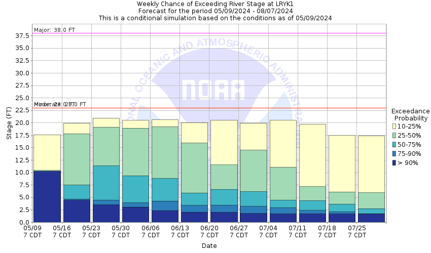
This probabilistic forecast is issued by the Arkansas Red-Basin River Forecast Center.
tab left off Hydrograph tab right off tab left off River at a Glance tab right off tab left off Download tab right off tab left on tab right on
About this graph
Forecasts for the Neosho River at Le Roy are issued as needed during times of high water, but are not routinely available.
Return to Area Map

Upstream Gauge - at Burlington Upstream Gauge Downstream Gauge Downstream Gauge - at Iola
Zoom Level:16
Flood Categories (in feet)
Major Flood Stage: 38
Moderate Flood Stage: 23
Flood Stage: 23
Action Stage: 18
Low Stage (in feet): -9999

Historic Crests
(1) 34.48 ft on 07/12/1951
(2) 30.73 ft on 07/22/1948
(3) 29.60 ft on 09/12/1926
(4) 29.55 ft on 05/25/2019
(5) 29.20 ft on 04/17/1945
(6) 29.20 ft on 06/05/1904
(7) 28.70 ft on 07/01/2007
(8) 28.65 ft on 07/20/1948
(9) 28.50 ft on 01/06/1941
(10) 28.00 ft on 11/04/1998
Show More Historic Crests

(P): Preliminary values subject to further review.

Recent Crests
(1) 29.55 ft on 05/25/2019
(2) 23.18 ft on 05/14/2019
(3) 27.70 ft on 05/24/2015
(4) 23.75 ft on 09/09/2009
(5) 28.70 ft on 07/01/2007
(6) 24.75 ft on 06/13/2005
(7) 25.95 ft on 06/05/2005
(8) 26.50 ft on 03/05/2004
(9) 20.90 ft on 05/04/1999
(10) 28.00 ft on 11/04/1998
Show More Recent Crests

(P): Preliminary values subject to further review.

Low Water Records
Currently none available.
KML Image
Gauge LocationGauge Map Marker
Disclaimer
Latitude/Longitude Disclaimer: The gauge location shown in the above map is the approximate location based on the latitude/longitude coordinates provided to the NWS by the gauge owner.
Flood Impacts & Photos Collapse
If you notice any errors in the below information, please contact our Webmaster
43 Flood waters reach the top of the bridge deck on Reaper Lane over the Neosho River.
42.2 Flood waters reach the top of the bridge curb at the left bridge abutment.
37 Flood waters reach the low steel of the bridge over the Neosho River.
36 The east bank of the river floods.
27 The Missouri, Pacific and the Missouri, Kansas and Texas Railroad tracks overflow.
23 Significant overflows begin and about 100 acres of land nearby are inundated. The road under the railroad viaduct on the right bank floods.
21 At this stage the river is at bankfull and minor overflows begin and the road to Moody begins to flood.
Collaborative Agencies Collapse
The National Weather Service prepares its forecasts and other services in collaboration with agencies like the US Geological Survey, US Bureau of Reclamation, US Army Corps of Engineers, Natural Resource Conservation Service, National Park Service, ALERT Users Group, Bureau of Indian Affairs, and many state and local emergency managers across the country. For details, please click here.
NWS Information
National Weather Service
Topeka Weather Forecast Office
1116 NE Strait Ave.
Topeka, KS 66616-1698
(785) 234-2592
Ask Questions/Webmaster
Page last modified: 2-Nov-2020 7:29 PM
Disclaimer
Credits
Glossary
Privacy Policy
About Us
Career Opportunities