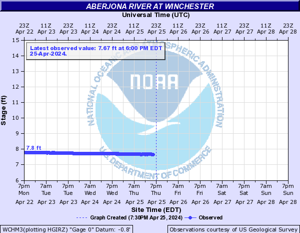
Aberjona River (Click on an image to go to hydrograph webpage)
WCHM3:
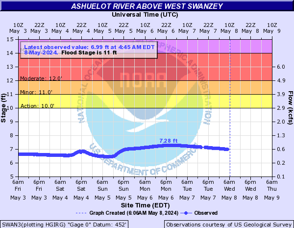
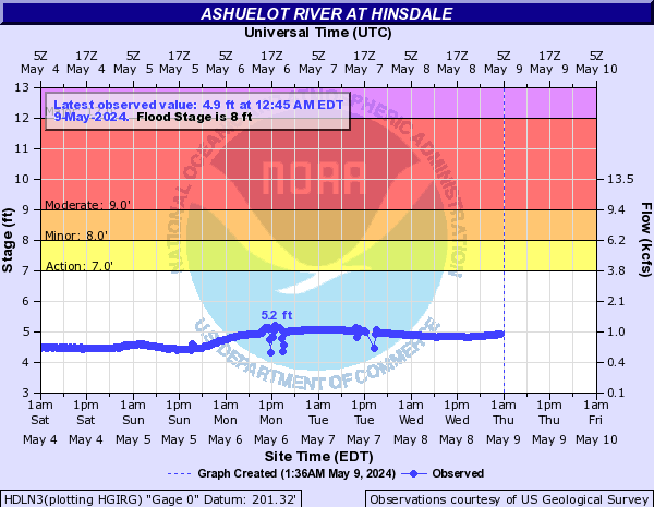
Ashuelot River (Click on an image to go to hydrograph webpage)
SWAN3:
HDLN3:
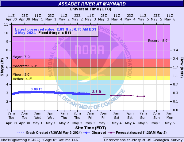
Assabet River (Click on an image to go to hydrograph webpage)
MAYM3:
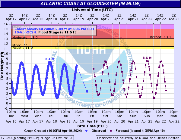
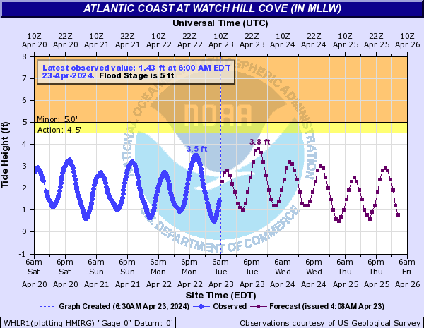
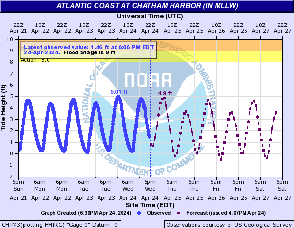
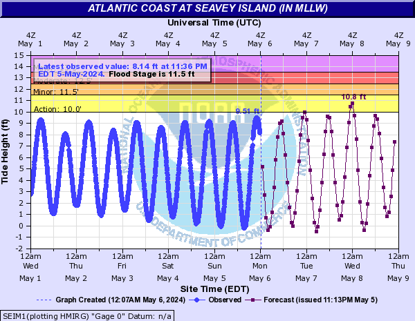
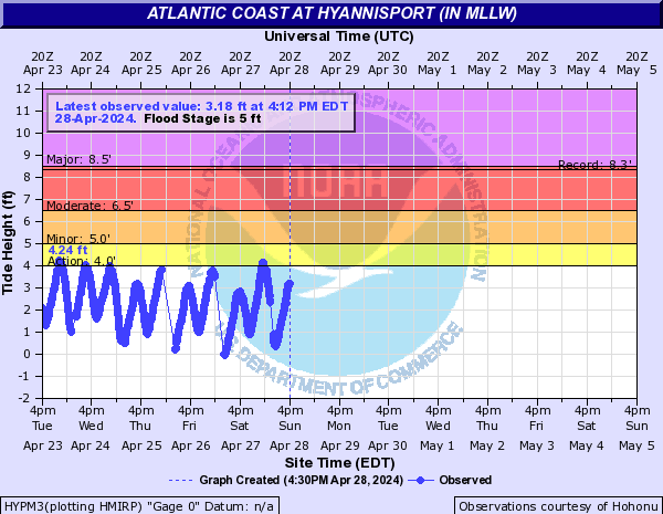
Atlantic Coast (Click on an image to go to hydrograph webpage)
GLCM3:
PVHM3:

WHLR1:
HPMN3:

CHTM3:
SEIM1:
SESM3:

HYPM3:
WELM1:
SANM3:

POPM3:

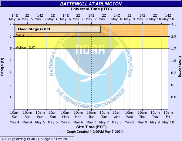
Battenkill (Click on an image to go to hydrograph webpage)
ARLV1:
BTTN6:

Blackstone River (Click on an image to go to hydrograph webpage)
NBRM3:

WOOR1:

WFWR1:

Boston Harbor (Click on an image to go to hydrograph webpage)
BHBM3:

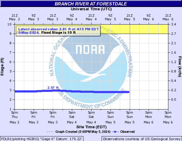
Branch River (Click on an image to go to hydrograph webpage)
FDLR1:
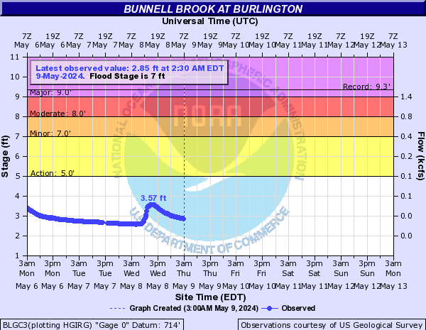
Bunnell Brook (Click on an image to go to hydrograph webpage)
BLGC3:
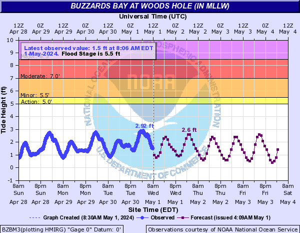
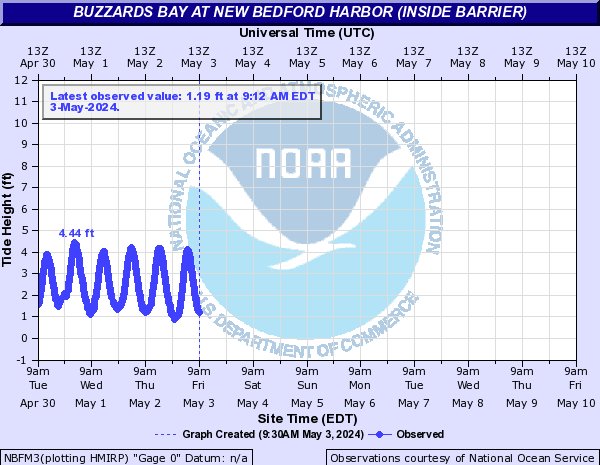
Buzzards Bay (Click on an image to go to hydrograph webpage)
BZBM3:
NBDM3:

NBFM3:
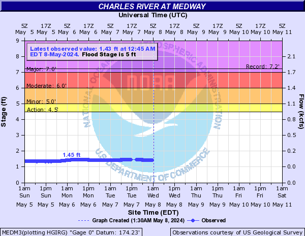
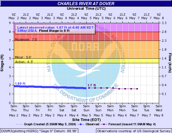
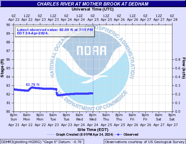
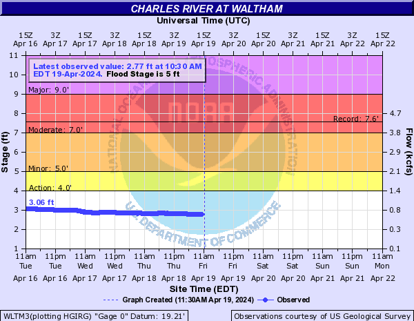
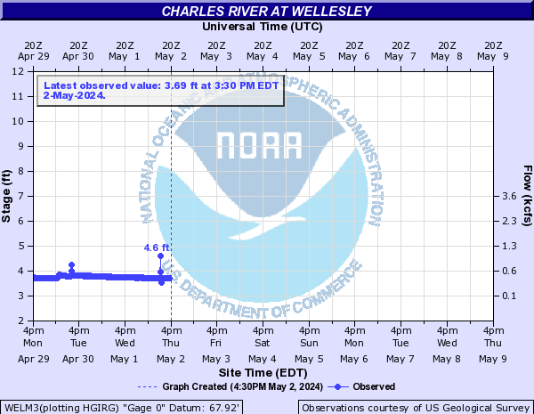
Charles River (Click on an image to go to hydrograph webpage)
MEDM3:
DOVM3:
DDHM3:
WLTM3:
WELM3:
Chicopee River (Click on an image to go to hydrograph webpage)
INDM3:

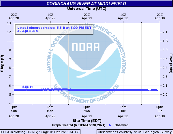
Coginchaug River (Click on an image to go to hydrograph webpage)
COGC3:
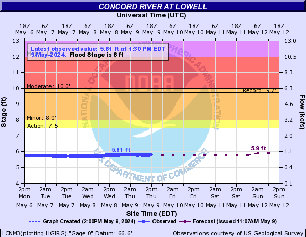
Concord River (Click on an image to go to hydrograph webpage)
LCNM3:
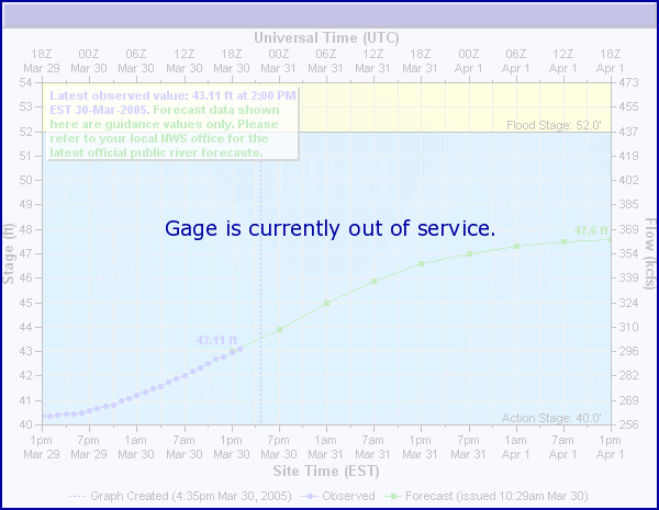
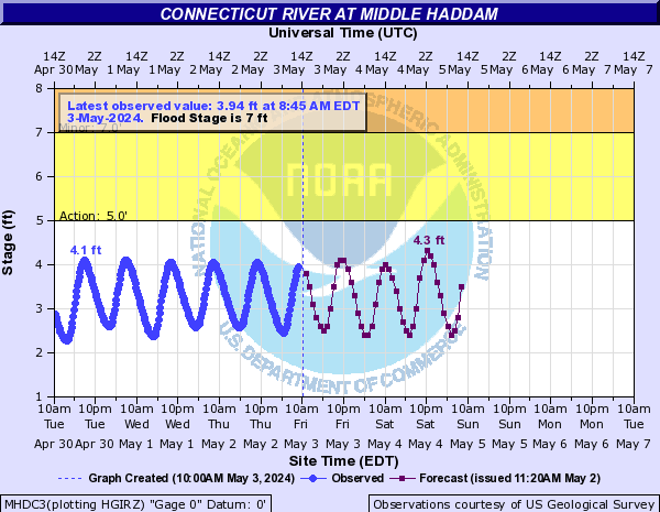
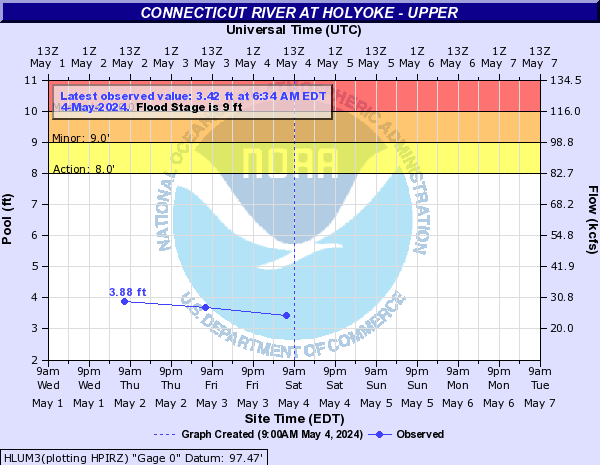
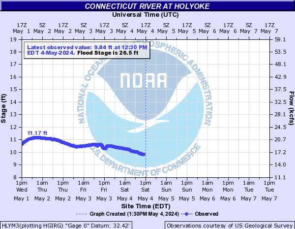
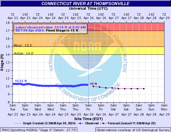
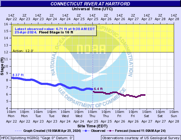
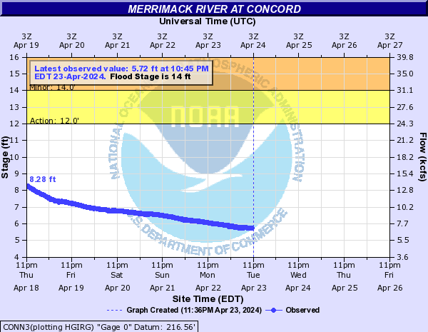
Connecticut River (Click on an image to go to hydrograph webpage)
MHDC3:
MNTM3:

NHMM3:

HLUM3:
HLYM3:
WLPN3:

SPGM3:

TMVC3:
HFDC3:
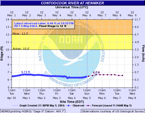
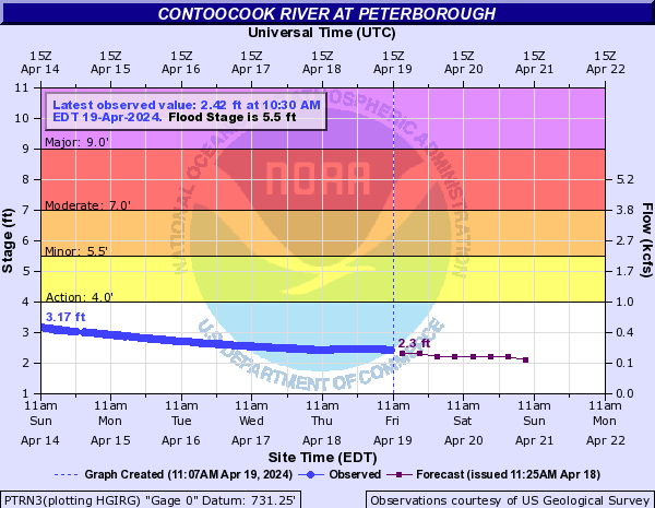
Contoocook River (Click on an image to go to hydrograph webpage)
HENN3:
PTRN3:
RVHN3:

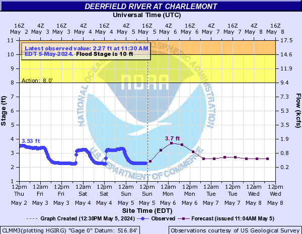
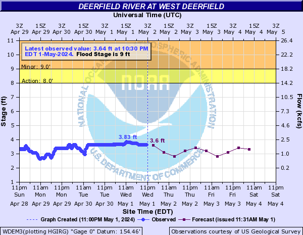
Deerfield River (Click on an image to go to hydrograph webpage)
CLMM3:
WDEM3:
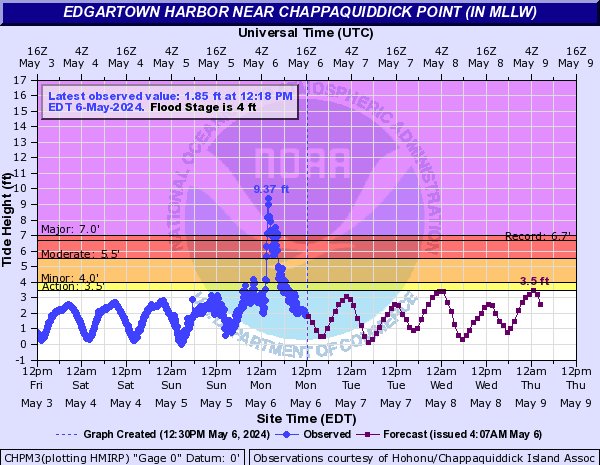
Edgartown Harbor (Click on an image to go to hydrograph webpage)
CHPM3:
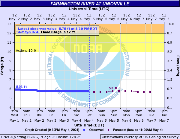
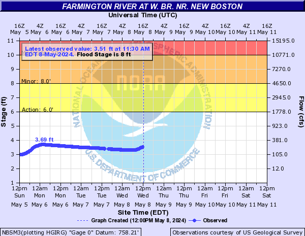
Farmington River (Click on an image to go to hydrograph webpage)
UNVC3:
NBSM3:
SIMC3:

TARC3:

Flax Pond (Click on an image to go to hydrograph webpage)
FLXN6:

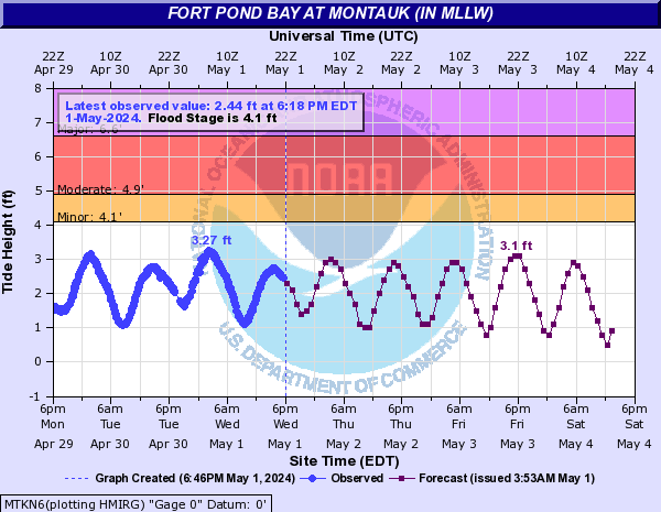
Fort Pond Bay (Click on an image to go to hydrograph webpage)
MTKN6:
Great Creek (Click on an image to go to hydrograph webpage)
EDBC3:

Green River (Click on an image to go to hydrograph webpage)
CRNM3:

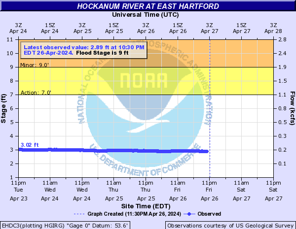
Hockanum River (Click on an image to go to hydrograph webpage)
EHDC3:
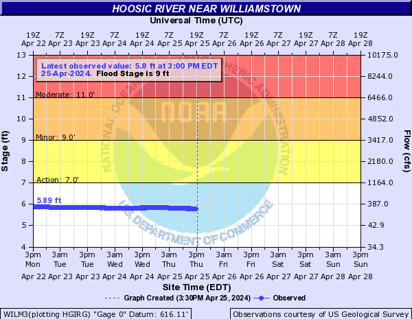
Hoosic River (Click on an image to go to hydrograph webpage)
WILM3:
EAGN6:

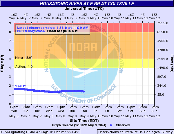
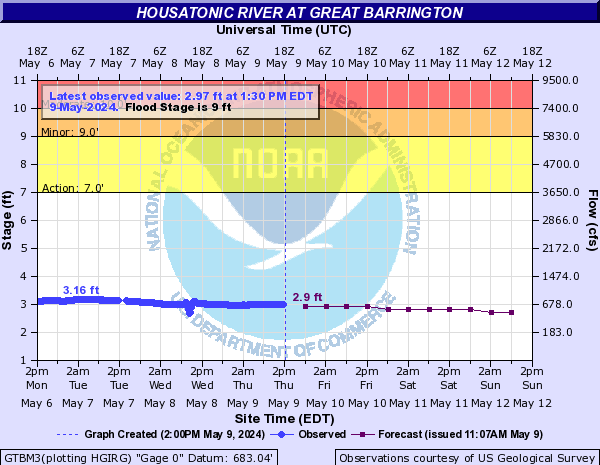
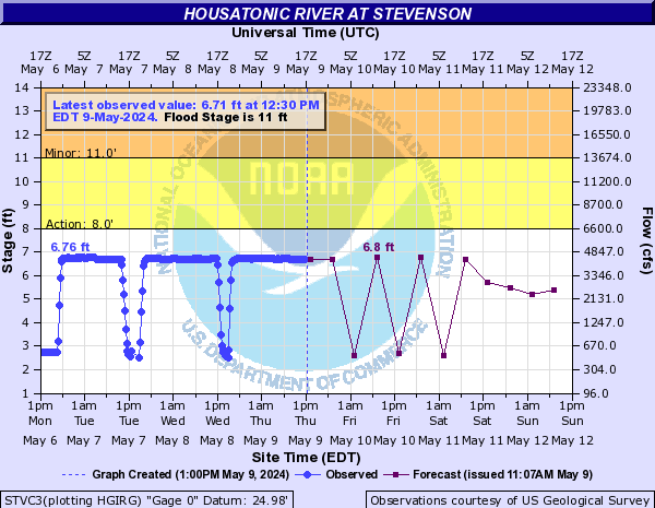
Housatonic River (Click on an image to go to hydrograph webpage)
WELC3:

CTVM3:
GTBM3:
FLVC3:

GAYC3:

LLIC3:

STVC3:
Ipswich River (Click on an image to go to hydrograph webpage)
IPSM3:

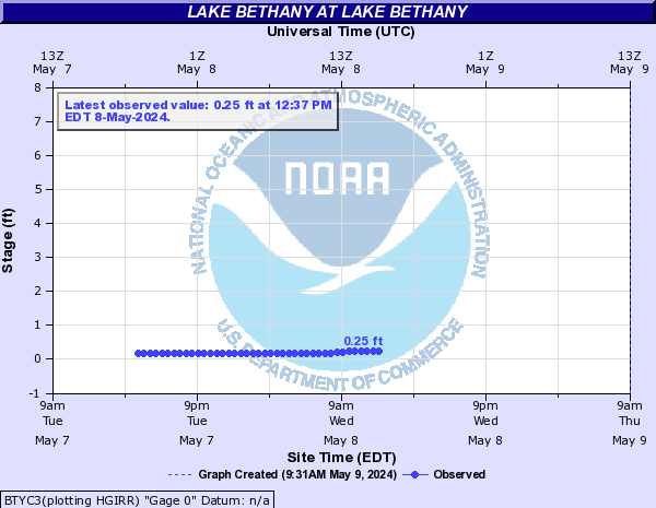
Lake Bethany (Click on an image to go to hydrograph webpage)
BTYC3:
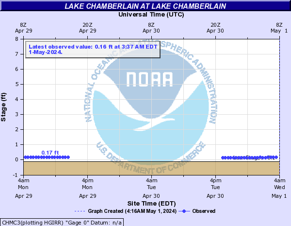
Lake Chamberlain (Click on an image to go to hydrograph webpage)
CHMC3:
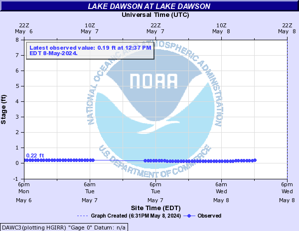
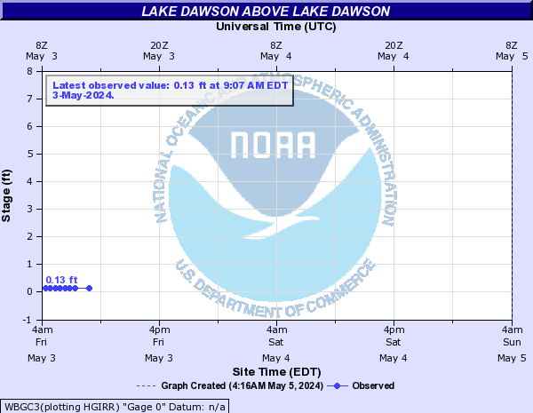
Lake Dawson (Click on an image to go to hydrograph webpage)
DAWC3:
WBGC3:
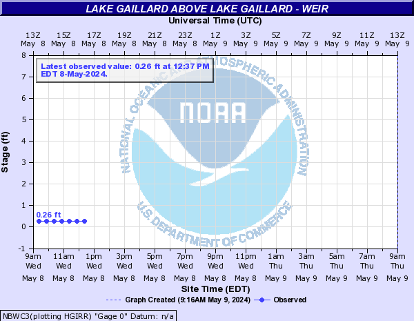
Lake Gaillard (Click on an image to go to hydrograph webpage)
NBWC3:
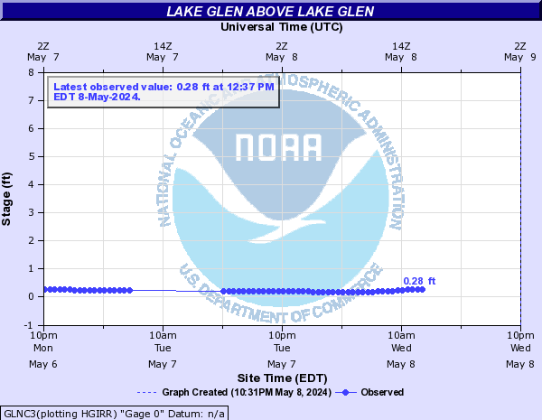
Lake Glen (Click on an image to go to hydrograph webpage)
GLNC3:
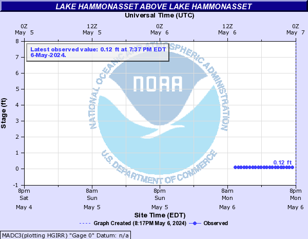
Lake Hammonasset (Click on an image to go to hydrograph webpage)
MADC3:
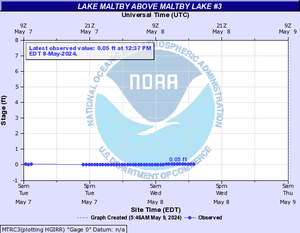
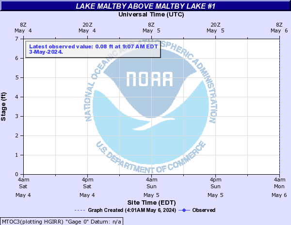
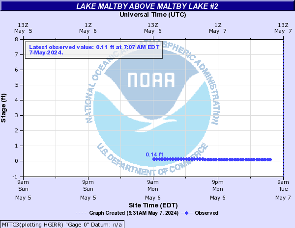
Lake Maltby (Click on an image to go to hydrograph webpage)
MTRC3:
MTOC3:
MTTC3:
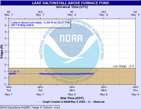
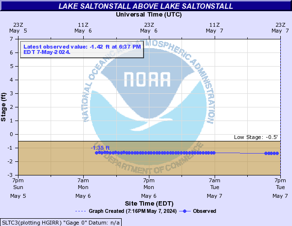
Lake Saltonstall (Click on an image to go to hydrograph webpage)
EHVC3:
SLTC3:
Lamprey River (Click on an image to go to hydrograph webpage)
LAMN3:

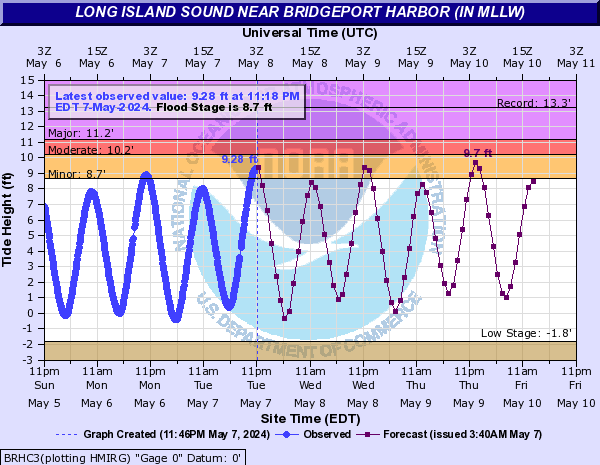
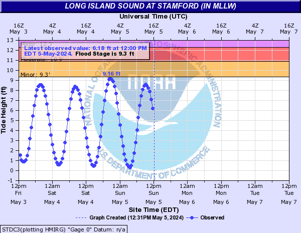
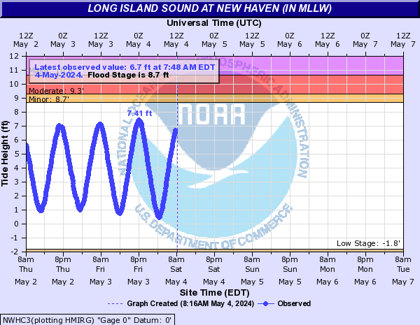
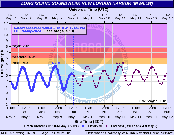
Long Island Sound (Click on an image to go to hydrograph webpage)
BRHC3:
CPBC3:
STDC3:
NWHC3:
NLHC3:
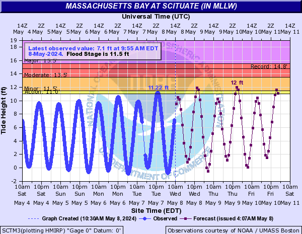
Massachusetts Bay (Click on an image to go to hydrograph webpage)
SCTM3:
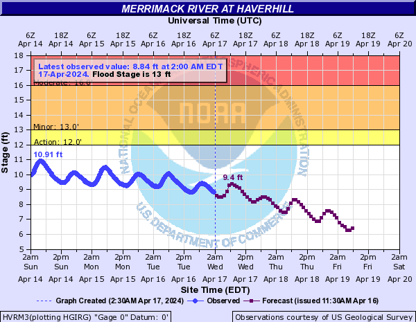
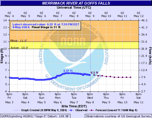
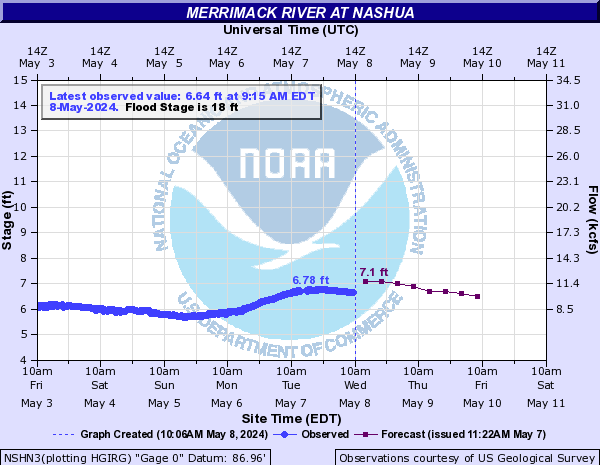
Merrimack River (Click on an image to go to hydrograph webpage)
LOWM3:

CONN3:
HVRM3:
LAWM3:

GOFN3:
NSHN3:
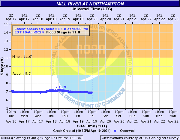
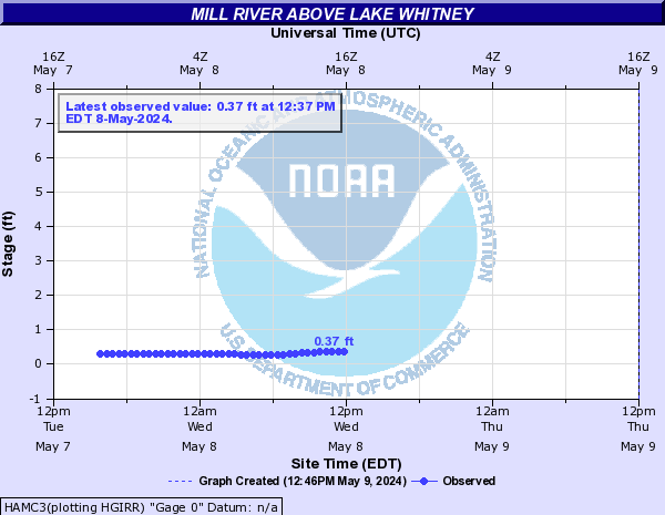
Mill River (Click on an image to go to hydrograph webpage)
NMIM3:
HAMC3:
TNMM3:

Millers River (Click on an image to go to hydrograph webpage)
ATHM3:

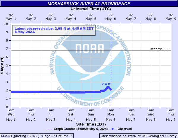
Moshassuck River (Click on an image to go to hydrograph webpage)
MOSR1:
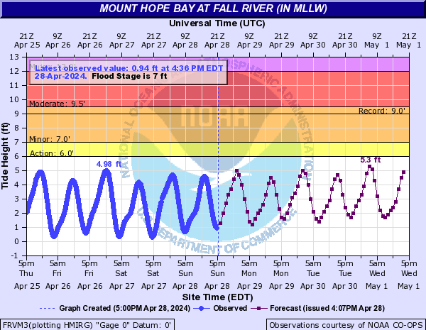
Mount Hope Bay (Click on an image to go to hydrograph webpage)
FRVM3:
Mount Hope River (Click on an image to go to hydrograph webpage)
WRNC3:

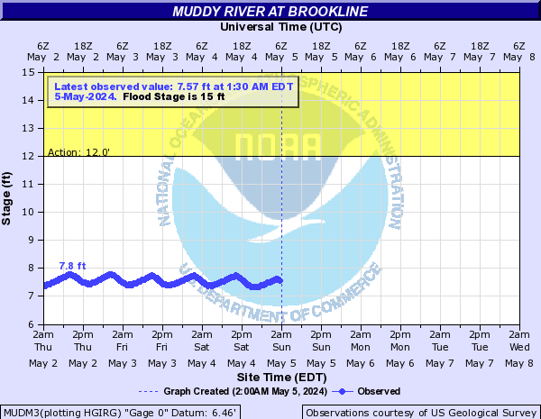
Muddy River (Click on an image to go to hydrograph webpage)
MUDM3:
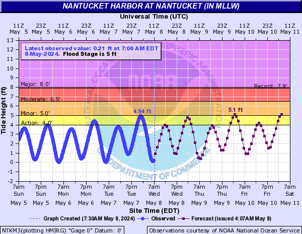
Nantucket Harbor (Click on an image to go to hydrograph webpage)
NTKM3:
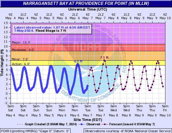
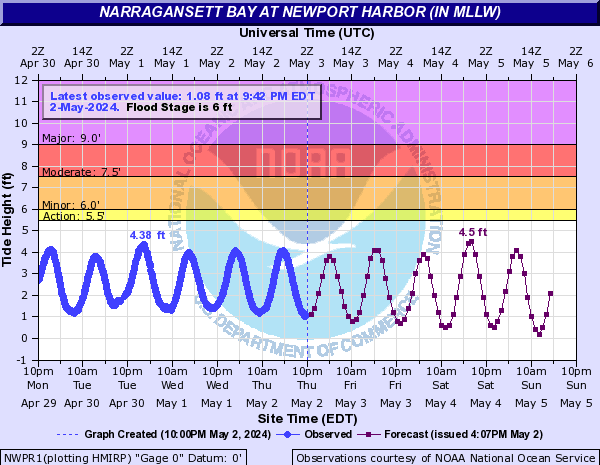
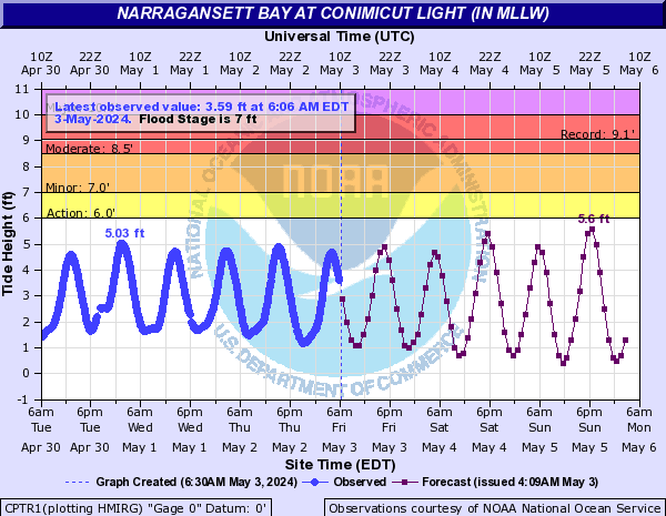
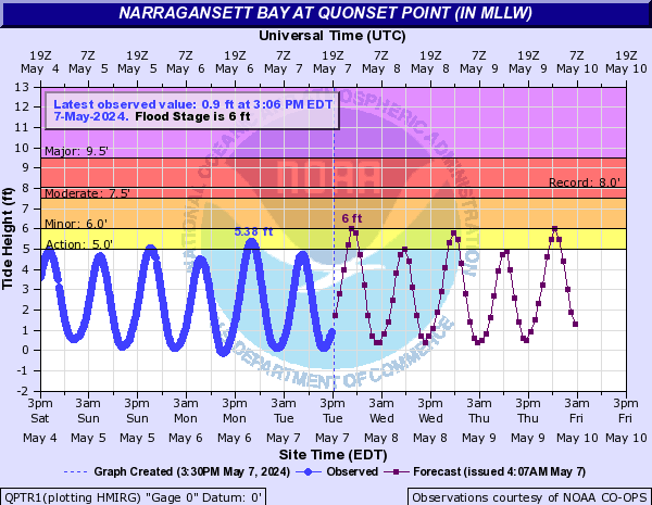
Narragansett Bay (Click on an image to go to hydrograph webpage)
FOXR1:
NWPR1:
CPTR1:
QPTR1:
Nashua River (Click on an image to go to hydrograph webpage)
DNSM3:

Naugatuck River (Click on an image to go to hydrograph webpage)
BEAC3:

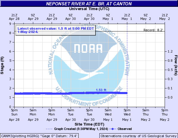
Neponset River (Click on an image to go to hydrograph webpage)
NRWM3:

CANM3:
MLTM3:

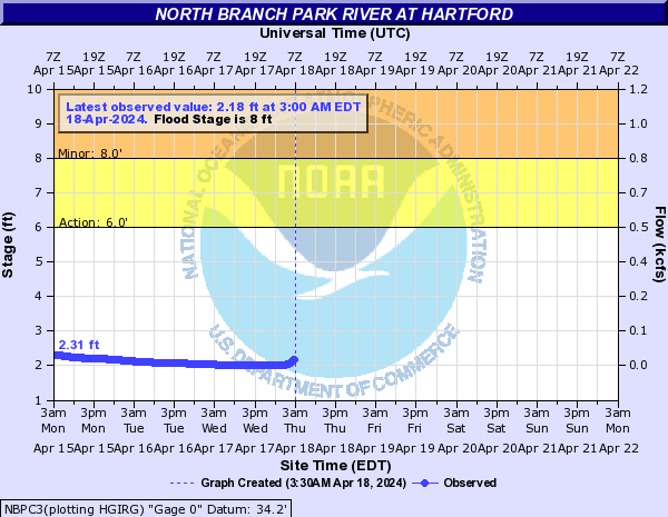
North Branch Park River (Click on an image to go to hydrograph webpage)
NBPC3:
North Branch Pawtuxet River (Click on an image to go to hydrograph webpage)
SCIR1:

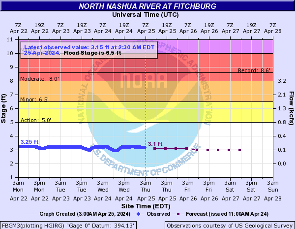
North Nashua River (Click on an image to go to hydrograph webpage)
FBGM3:
North River (Click on an image to go to hydrograph webpage)
SHVM3:

Orient Harbor (Click on an image to go to hydrograph webpage)
ORIN6:

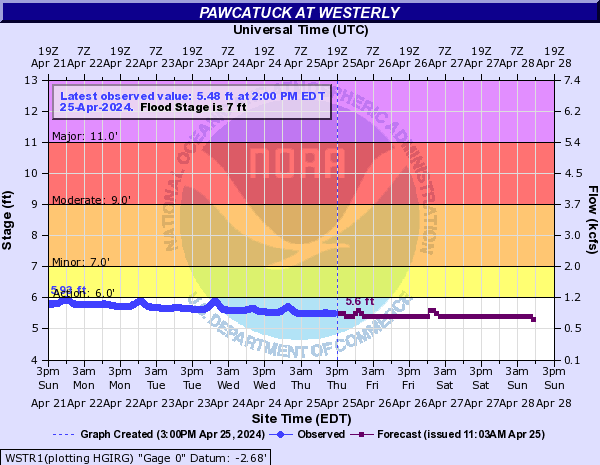
Pawcatuck (Click on an image to go to hydrograph webpage)
WSTR1:
WODR1:

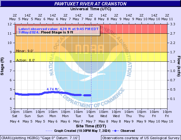
Pawtuxet River (Click on an image to go to hydrograph webpage)
CRAR1:
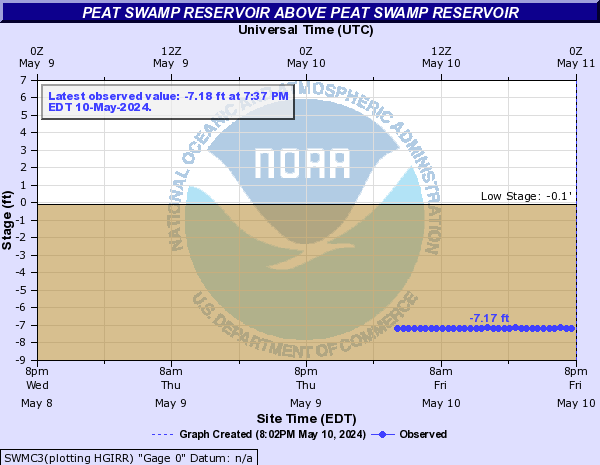
Peat Swamp Reservoir (Click on an image to go to hydrograph webpage)
SWMC3:
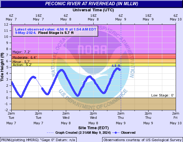
Peconic River (Click on an image to go to hydrograph webpage)
PRIN6:
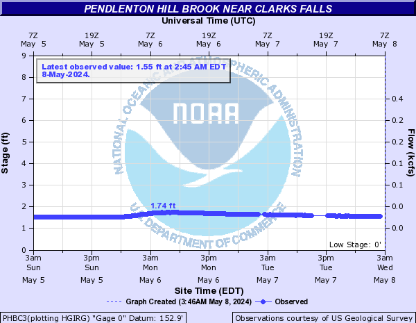
Pendlenton Hill Brook (Click on an image to go to hydrograph webpage)
PHBC3:
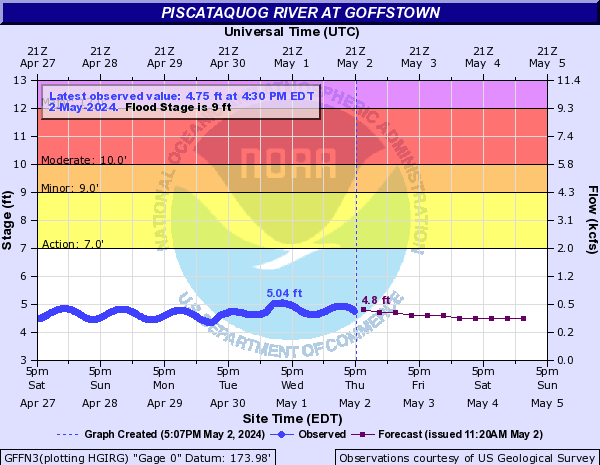
Piscataquog River (Click on an image to go to hydrograph webpage)
GFFN3:
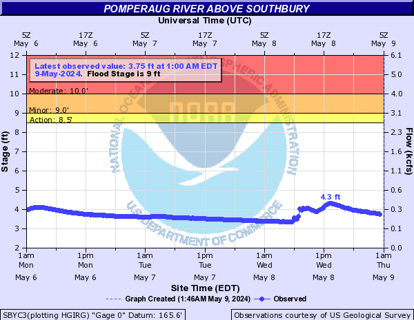
Pomperaug River (Click on an image to go to hydrograph webpage)
SBYC3:
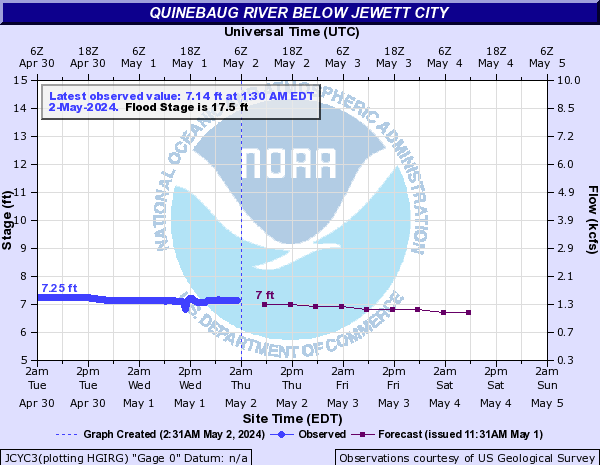
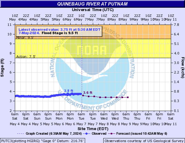
Quinebaug River (Click on an image to go to hydrograph webpage)
JCYC3:
PUTC3:
Quinnipiac River (Click on an image to go to hydrograph webpage)
WALC3:

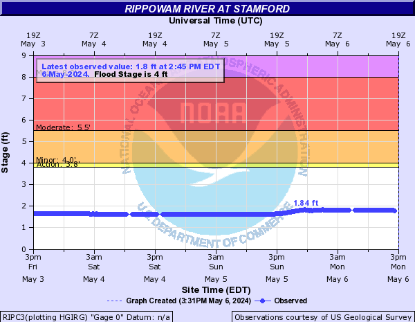
Rippowam River (Click on an image to go to hydrograph webpage)
RIPC3:
Segregansett River (Click on an image to go to hydrograph webpage)
DIGM3:

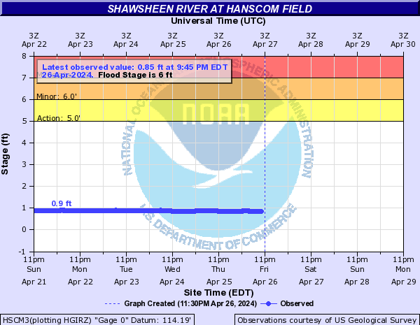
Shawsheen River (Click on an image to go to hydrograph webpage)
WLMM3:

ANDM3:

HSCM3:
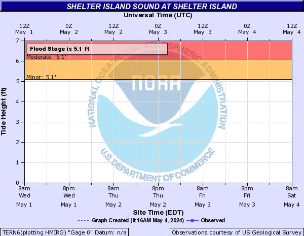
Shelter Island Sound (Click on an image to go to hydrograph webpage)
TERN6:
Shetucket River (Click on an image to go to hydrograph webpage)
WLMC3:

Soucook River (Click on an image to go to hydrograph webpage)
SOUN3:

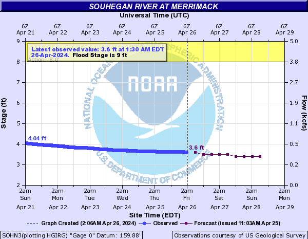
Souhegan River (Click on an image to go to hydrograph webpage)
SOHN3:
MFDN3:

South Branch Pawtuxet River (Click on an image to go to hydrograph webpage)
WASR1:

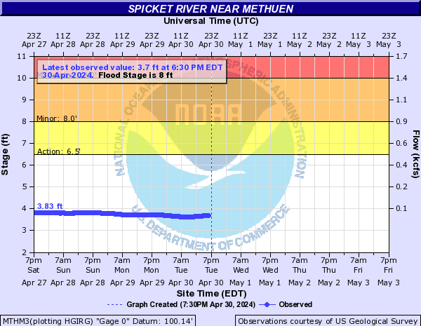
Spicket River (Click on an image to go to hydrograph webpage)
MTHM3:
Squannacook River (Click on an image to go to hydrograph webpage)
WGTM3:

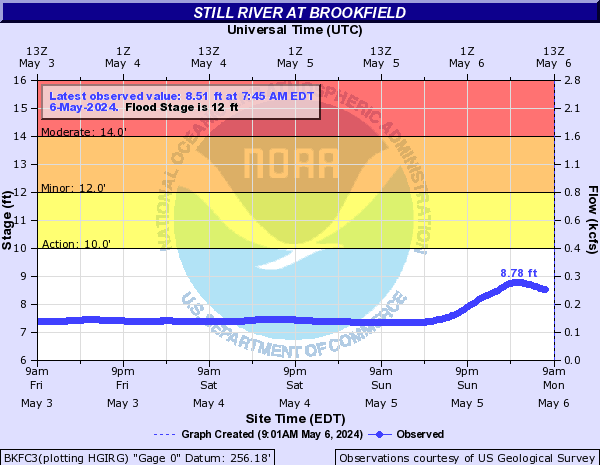
Still River (Click on an image to go to hydrograph webpage)
BKFC3:
Sudbury River (Click on an image to go to hydrograph webpage)
SAXM3:

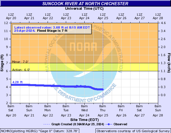
Suncook River (Click on an image to go to hydrograph webpage)
NCHN3:
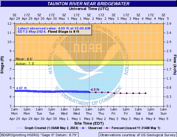
Taunton River (Click on an image to go to hydrograph webpage)
BDGM3:
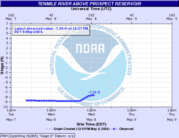
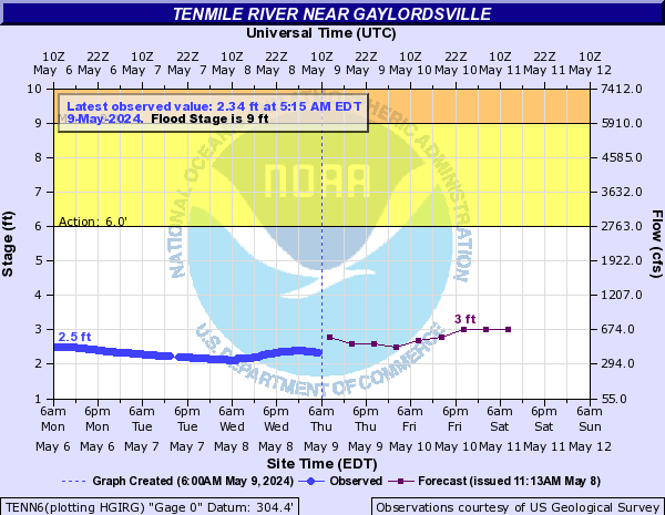
Tenmile River (Click on an image to go to hydrograph webpage)
PRPC3:
TENN6:
Vineyard Sound (Click on an image to go to hydrograph webpage)
VNHM3:
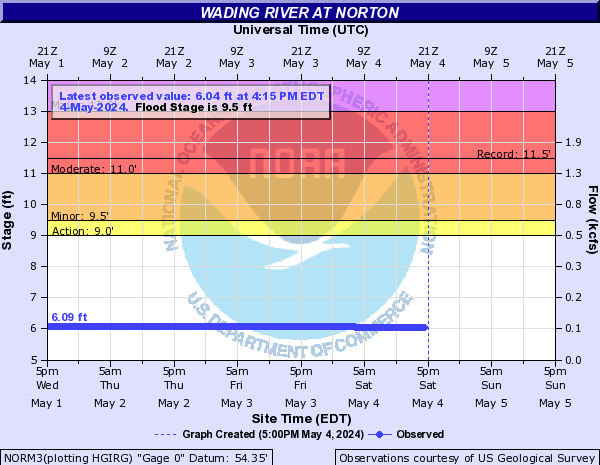
Wading River (Click on an image to go to hydrograph webpage)
NORM3:
Walloomsac River (Click on an image to go to hydrograph webpage)
BNTV1:

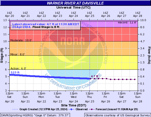
Warner River (Click on an image to go to hydrograph webpage)
DAVN3:
West Branch Westfield River (Click on an image to go to hydrograph webpage)
HNTM3:

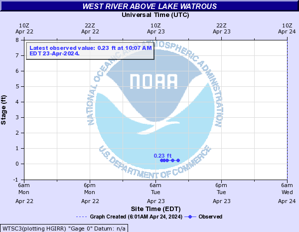
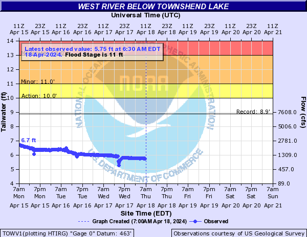
West River (Click on an image to go to hydrograph webpage)
WTSC3:
TOWV1:
Westfield River (Click on an image to go to hydrograph webpage)
WSFM3:

Williams River (Click on an image to go to hydrograph webpage)
RKGV1:

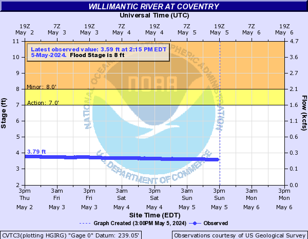
Willimantic River (Click on an image to go to hydrograph webpage)
CVTC3:
Wood River (Click on an image to go to hydrograph webpage)
HOPR1:

Woonasquatucket (Click on an image to go to hydrograph webpage)
CENR1:

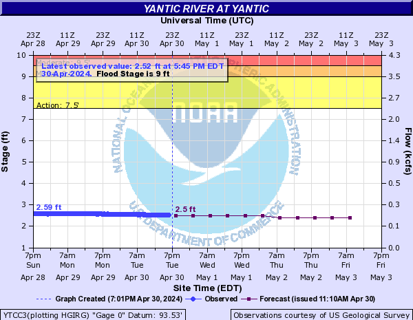
Yantic River (Click on an image to go to hydrograph webpage)
YTCC3: