Skip Navigation Link weather.gov  
NOAA logo - Click to go to the NOAA homepage National Weather Service NWS logo - Click to go to the NWS homepage
Advanced Hydrologic Prediction Service
Image background of Navigation bar Left
Navigation Bar End Cap


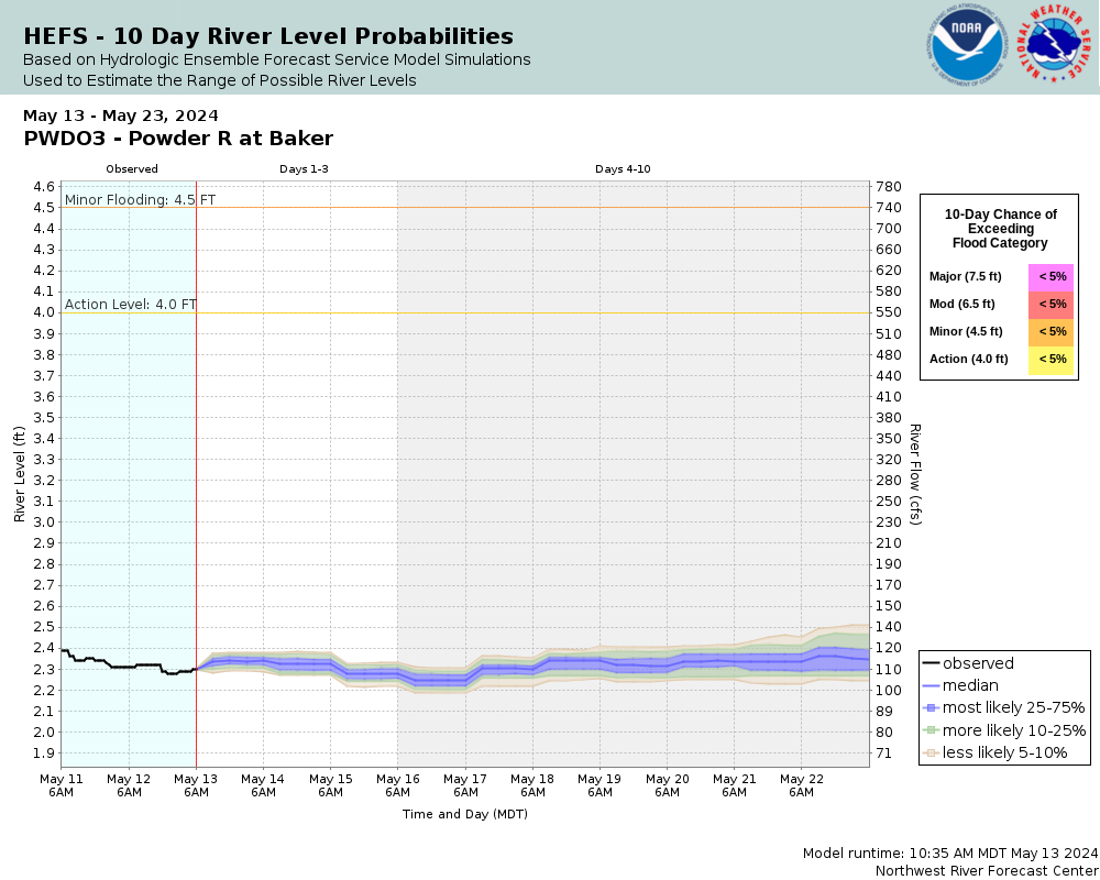
This probabilistic forecast is issued by the Northwest River Forecast Center.
tab left off Hydrograph tab right off tab left off River at a Glance tab right off tab left off Download tab right off tab left on tab right on
Experimental Short Range Forecast Uncertainty (AHPS) - External Links: Product Description Document | Customer Survey
About this graph
Forecasts for the Powder River (OR) at Baker City are issued routinely year-round.
Return to Area Map

Upstream Locations Upstream Gauge
Zoom Level:14
Flood Categories (in feet)
Major Flood Stage: 7.5
Moderate Flood Stage: 6.5
Flood Stage: 4.5
Action Stage: 4
Low Stage (in feet): -9999

Historic Crests
(1) 5.36 ft on 02/13/1979
(2) 4.80 ft on 01/01/1997
(3) 4.75 ft on 03/11/1989
(4) 4.73 ft on 07/01/1982
(5) 4.62 ft on 08/31/1984
Show More Historic Crests

(P): Preliminary values subject to further review.

Recent Crests
(1) 3.08 ft on 05/29/2022
(2) 3.47 ft on 05/08/2021
(3) 3.48 ft on 05/20/2020
(4) 3.53 ft on 04/09/2019
(5) 3.49 ft on 08/02/2018
Show More Recent Crests

(P): Preliminary values subject to further review.

Low Water Records
Currently none available.
KML Image
Gauge LocationGauge Map Marker
Disclaimer
Latitude/Longitude Disclaimer: The gauge location shown in the above map is the approximate location based on the latitude/longitude coordinates provided to the NWS by the gauge owner.
Flood Impacts & Photos Collapse
If you notice any errors in the below information, please contact our Webmaster
7.5 Water will overflow the river bank in portions of Baker City with water likely entering some businesses and houses near the river. The flooding will be worse in the vicinity of bridge crossings were water will be deeper and back up behind bridges. Flood water will flow into the park near the library. The area near Hughes Lane and Kirkway Drive will be flooded. Agricultural land adjacent to the river, both upstream and downstream from Baker City, will be flooded.
6.5 Flooding will affect portions of Baker City near the river especially near bridge crossings where water may back up. Portions of the greenbelt recreation path will be flooded. Flooding will affect portions of Kirkway Drive and Huges Lane. Flooding may also spill into the park by the library.
6 Minor flooding will occur near the river in Baker City. Portions of the greenbelt recreation path will be flooded. Floodwaters will reach Kirkway Drive near Hughes Lane.
4.5 Minor flooding can be expected along portions of the greenbelt path adjacent to the river in Baker City. Some minor agricultural flooding may occur well upstream and downstream from Baker City.
4 The river will approach bankfull through Baker City and some bank erosion may occur.
Photos
(1) Powder River at Baker City looking downstream
(2) Powder River at Baker City gage house
(3) Powder River at Baker City looking upstream
Collaborative Agencies Collapse
The National Weather Service prepares its forecasts and other services in collaboration with agencies like the US Geological Survey, US Bureau of Reclamation, US Army Corps of Engineers, Natural Resource Conservation Service, National Park Service, ALERT Users Group, Bureau of Indian Affairs, and many state and local emergency managers across the country. For details, please click here.
NWS Information
National Weather Service
Boise Weather Forecast Office
NIFC Building 3807
Boise, ID 83705-5354
(208) 334-9860
Ask Questions/Webmaster
Page last modified: 2-Nov-2020 7:28 PM
Disclaimer
Credits
Glossary
Privacy Policy
About Us
Career Opportunities