| If you notice any errors in the below information, please contact our Webmaster |
| 25.1 |
FEMA flood insurance maps indicate that a river level of 25.1 feet corresponds to the water elevation associated with the 0.2 percent (500-year) flood zone. If your property is determined to be in this zone, then it is at high risk for flooding during a record flood event. This magnitude of flood is a flood that has a 0.2 percent chance of occurring in any year. |
| 23.6 |
This is the all-time, historic flood record before the existence of the stream gauge at this location. The flood occurred on October 9, 1903, and is commonly known as the Pumpkin Flood. |
| 21.45 |
This is the modern day flood of record from June, 2006. Widespread flooding occurred from Fishs Eddy to Hancock with catastrophic property and infrastructure damages. |
| 21.4 |
This was the level of the September 18, 2004 flood which was considered to be a major flood. |
| 21 |
FEMA flood insurance maps indicate that a river level of 21.0 feet corresponds to the water elevation associated with the 1 percent (100 year) flood zone. If your property is determined to be in this zone, then it is at high risk for flooding during a major flood. This magnitude of flood is a flood level that has a 1 percent chance of occuring in any year. |
| 20.6 |
This is the highest flood level which occurred before construction of the Downsville Dam, and after installation of the stream gauge. August 24, 1933. |
| 19.47 |
This is the flood level from the April, 2005 flood and was considered to be major flooding. |
| 18 |
Major Flood Stage. Above 18 feet, serious river flooding is widespread from Fish Eddy to Hancock. Bodoit Road is under water in Fishs Eddy. O and W Circle and County Route 28 are flooded. Portions of Old Route 17 are cut off by flooding. Cadosia Road and County Route 268 flood. In the Village of Hancock, thre is significant flooding along E. Front Street, and behind Mill, Yendes and most of Park streets. LaBarre Street is inundated south of Forester Boulevard affecting several homes and businesses. |
| 16.88 |
This is the flood level from the January, 1996 flood and was considered to be a moderate flood. |
| 16.21 |
This is the flood level from the October 1, 2010 flood and was considered to be a moderate flood. |
| 16.04 |
This is the flood level from the remnants of Hurricane Irene in August, 2011 and was considered to be a moderate flood. |
| 16 |
Moderate Flood Stage. Between 16 and 18 feet, river water crosses several portions of Bodoit Road, Peas Eddy Road, Peters Road and Green Flats road from Fishs Eddy to Hancock. The industrial are off Old Route 17 in Fishs Eddy is flooded. In Hancock, river water spreads into homes along E. Front Street and completely floods the park and ballfields. |
| 15.79 |
This is the flood level from the remnants of Tropical Storm Lee flood and was considered to be a minor flood. |
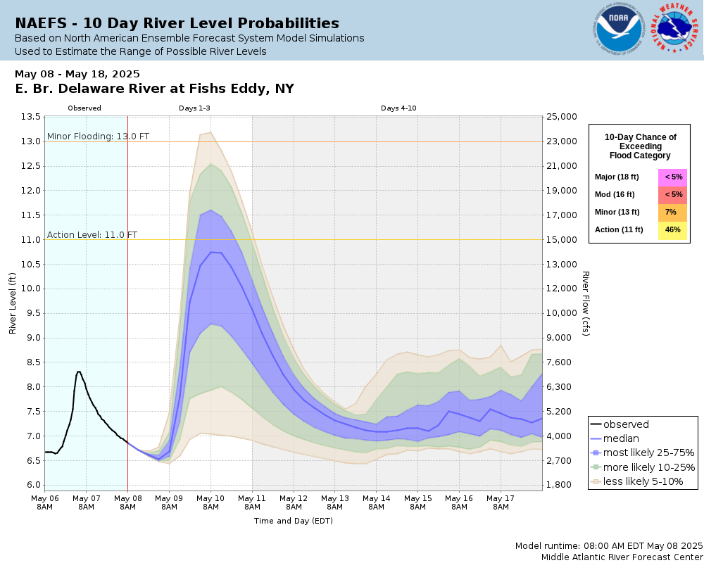
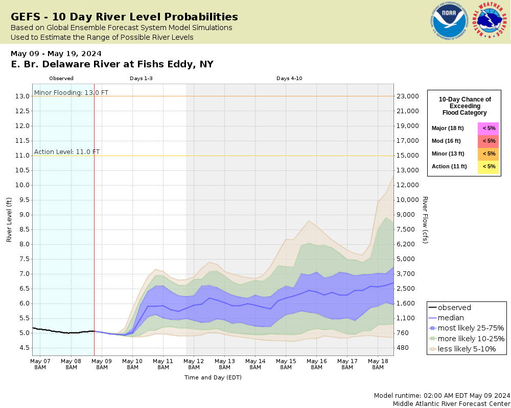
| 13 |
Minor Flood Stage. Between 13 and 16 feet, widespread agricultural flooding develops in the floodplain. River water approaches Bodoit Road in Fishs Eddy. In Hancock, properties along E. Front Street are affected. |