Historic Crests
(1) 37.45 ft on 05/15/2006
(2) 37.45 ft on 05/15/2006
(3) 36.16 ft on 03/16/2010
(4) 34.15 ft on 04/18/2007
(5) 33.98 ft on 04/01/2010 Show More Historic Crests
(P): Preliminary values subject to further review.
Recent Crests
(1) 30.84 ft on 01/12/2024
(2) 30.80 ft on 12/20/2023
(3) 29.09 ft on 09/21/2023
(4) 29.37 ft on 03/16/2023
(5) 29.21 ft on 09/04/2021 Show More Recent Crests
(P): Preliminary values subject to further review.
Latitude/Longitude Disclaimer: The gauge location shown in the above map
is the approximate location based on the latitude/longitude coordinates
provided to the NWS by the gauge owner.
Flood Impacts & Photos
If you notice any errors in the below information, please contact our Webmaster
38
Flood impacts are expected to be comparable to, or worse than, the May 2006 Floods. Impacts in North Andover will increase along Glenwood, Fernwood and Elmwood Streets, and both Mass Ave and Route 114 experience significant flooding at the Lawrence-North Andover Town line. Floodwaters impact large sections of Andover in the greater vicinity of North Main Street. Numerous residences, businesses and roadways are impacted.
36
In Andover, a stretch of North Main Street is impassable. Floodwaters inundate numerous residences and businesses in the greater vicinity of North Main. Impacted areas include but are not limited to Washington Park Condominiums, the Balmoral, Shawsheen Plaza, Powdermill Square, Ballardvale Falls, Gradall Lane and River Street. Flooding impacts Mass Ave underpass and businesses on Route 114 at the Lawrence/North Andover town line. In North Andover lower Glenwood, Elmwood and Fernwood Streets are impacted.
35
In North Andover floodwaters inundate lowest lying homes along Glenwood, Elmwood and Fernwood Streets. Floodwaters impact lowest lying businesses and parking lots along Route 114 and Mass Ave on the Lawrence-North Andover town line. In Andover, flood impacts spread to multiple locations along and off of North Main Street, including homes and businesses. Flood impact areas include but are not limited to Washington Park Condominiums, Shawsheen Plaza, Powdermill Square, Ballardvale Falls, and River Street.
34
In North Andover, floodwaters approach or inundate lowest lying homes along Glenwood, Elmwood and Fernwood Streets. Floodwaters impact lowest lying businesses and parking lots on Route 114 closest to the Shawsheen River on the Lawrence North Andover Town line. In Andover, floodwaters inundate some low lying structures along North Main Street. Within Andover, floodwaters approach lowest lying structures at Washington Park Condominiums, Shawsheen Plaza, Powdermill Square, Ballardvale Falls, and River Street.
32
Floodwaters impact lowest lying businesses and parking lots along Route 114 closest to the Shawsheen River on the Lawrence and North Andover town line. Floodwaters may reach the lowest lying homes along Glenwood Street in North Andover. In Andover, the very lowest lying homes and external structures along North Main Street are impacted. Floodwaters may affect River Street near Laconia Drive.
31
Floodwaters inundate the lowest lying parking lots along Route 114 adjacent to the Shawsheen River. This includes drainage fronting the North Andover Mall along Route 114. Floodwaters encroach on Route 114 hotel building in Lawrence, adjacent to the river. Floodwaters encroach on lowest lying properties along Glenwood Street in North Andover.
30
Floodwaters inundate very lowest lying business parking lots off Route 114 in Lawrence and North Andover that are adjacent to the Shawsheen River.
29
Floodwaters encroach on very lowest lying business parking lots off of Route 114 in Lawrence and North Andover that are adjacent to the Shawsheen River.
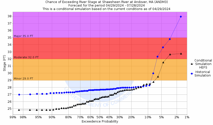
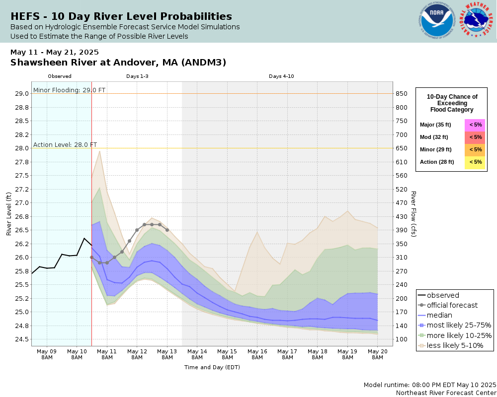
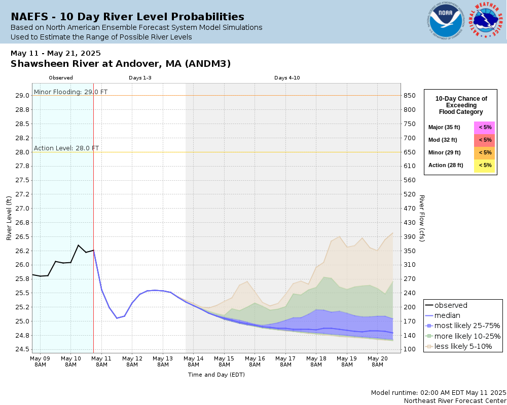
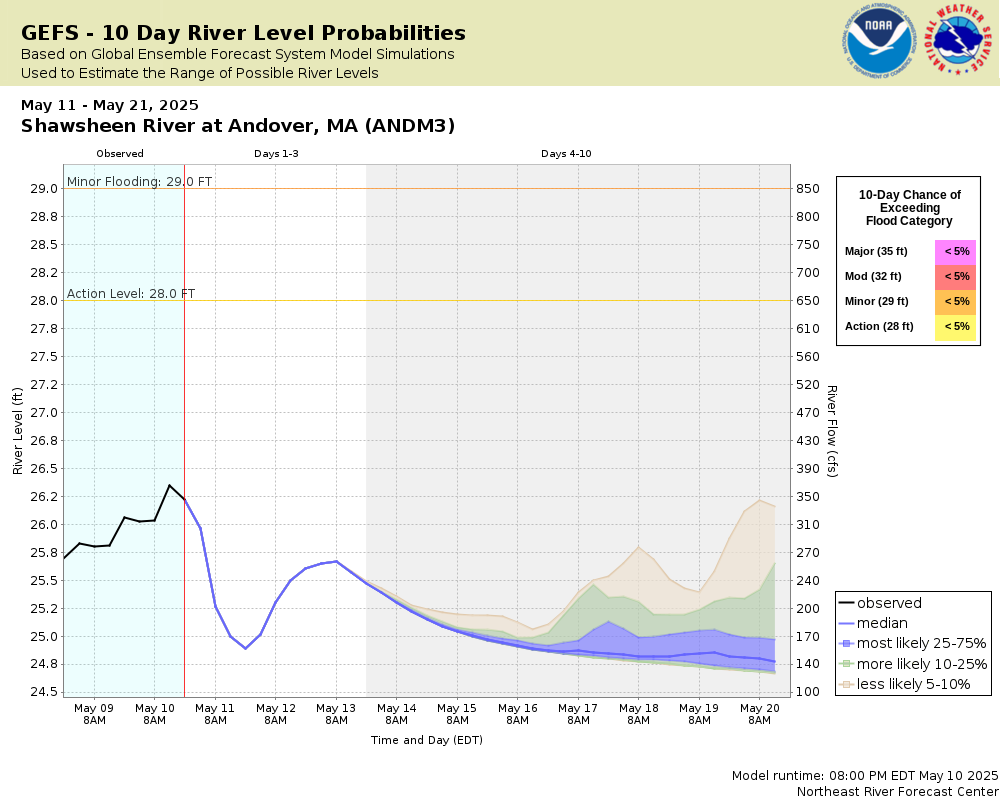
Potential River Levels Used to Estimate the Chance of Flooding and
the Range of Possible River Levels
10 Day (HEFS)
7 Day (NAEFS)
7 Day (GEFS)
Note: Use the official hydrograph at the top of this web page
for river levels within the next 72 Hours.
Click individual graphics to
enlarge.
Collaborative Agencies
The National Weather Service prepares its forecasts and other services in collaboration with agencies like the US Geological Survey, US Bureau of Reclamation, US Army Corps of Engineers, Natural Resource Conservation Service, National Park Service, ALERT Users Group, Bureau of Indian Affairs, and many state and local emergency managers across the country. For details, please click here.
NWS Information
National Weather Service
Boston / Norton Weather Forecast Office
46 Commerce Way
Norton, MA 02766
(508) 622-3250 Ask Questions/Webmaster
Page last modified: 2-Nov-2020 7:30 PM