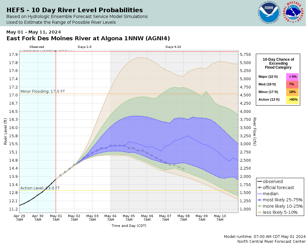
Skip Navigation Link weather.gov  
NOAA logo - Click to go to the NOAA homepage National Weather Service NWS logo - Click to go to the NWS homepage
Advanced Hydrologic Prediction Service
Image background of Navigation bar Left
Navigation Bar End Cap


This probabilistic forecast is issued by the North Central River Forecast Center.
tab left off Hydrograph tab right off tab left off River at a Glance tab right off tab left off Download tab right off tab left on tab right on
Experimental Short Range Forecast Uncertainty (AHPS) - External Links: Product Description Document | Customer Survey
About this graph
Forecasts for the East Fork Des Moines River near Algona are issued as needed during times of high water, but are not routinely available.

More information on datums is available at www.ngs.noaa.gov/faq.shtml

Return to Area Map

Downstream Gauge Downstream Gauge - at Dakota City
Zoom Level:14
Flood Categories (in feet)
Major Flood Stage: 22
Moderate Flood Stage: 18
Flood Stage: 17
Action Stage: 13
Low Stage (in feet): -9999

Historic Crests
(1) 22.65 ft on 04/01/1993
(2) 22.18 ft on 08/23/1979
(3) 19.31 ft on 06/26/2018
(4) 19.16 ft on 09/22/2018
(5) 18.63 ft on 03/17/2019
(6) 18.54 ft on 03/21/2019
(7) 17.58 ft on 06/19/2014
(8) 17.37 ft on 06/18/2014
(9) 16.57 ft on 05/29/2013
(10) 15.68 ft on 09/26/2016
Show More Historic Crests

(P): Preliminary values subject to further review.

Recent Crests
(1) 14.71 ft on 05/17/2023
(2) 12.35 ft on 05/03/2022
(3) 9.35 ft on 09/05/2021
(4) 15.47 ft on 05/20/2020
(5) 18.54 ft on 03/21/2019
(6) 18.63 ft on 03/17/2019
(7) 19.16 ft on 09/22/2018
(8) 19.31 ft on 06/26/2018
(9) 14.93 ft on 05/22/2017
(10) 15.68 ft on 09/26/2016
Show More Recent Crests

(P): Preliminary values subject to further review.

Low Water Records
Currently none available.
KML Image
Gauge LocationGauge Map Marker
Disclaimer
Latitude/Longitude Disclaimer: The gauge location shown in the above map is the approximate location based on the latitude/longitude coordinates provided to the NWS by the gauge owner.
Flood Impacts & Photos Collapse
If you notice any errors in the below information, please contact our Webmaster
22 Water affects the shopping center parking lot and approaches the buildings. Water also affects US 169 near and north of Saint Joseph. Water may also threaten many bridges over the Des Moines River in the area with washouts. Many roads across Kossuth County may be closed.
20 Water affects portions of US 18. Water enters the parking lot of the shopping center north of US 18 and west of the river.
19 Water affects US 169 south of Algona. US 169 near Saint Joseph will be cut off. Water also threatens sections of US 18 east of US 169.
18 Water threatens US 169 near Saint Joseph and may affect it south of Algona.
17 Water threatens US 169 south of Algona and affects some rural roads.
16.5 Water affects the lowest portions of Northpark Dr and Norwood Dr in Algona.
16 Widespread agricultural flooding occurs.
14 Water affects low-lying agricultural land along the river.

Other Real-time and/or Archive Data Sources:

Additional Information Collapse
  • USGS 7-Day Streamflow Duration Hydrograph for this location:
    Duration Hydrograph

    Duration Hydrograph Legend


  • USGS Cumulative Streamflow Hydrograph for this location:
    Duration Hydrograph of Cumulative Streamflow
Collaborative Agencies Collapse
The National Weather Service prepares its forecasts and other services in collaboration with agencies like the US Geological Survey, US Bureau of Reclamation, US Army Corps of Engineers, Natural Resource Conservation Service, National Park Service, ALERT Users Group, Bureau of Indian Affairs, and many state and local emergency managers across the country. For details, please click here.
NWS Information
National Weather Service
Des Moines Weather Forecast Office
9607 NW Beaver Dr.
Des Moines, IA 50131
(515) 270-2614
Ask Questions/Webmaster
Page last modified: 2-Nov-2020 7:29 PM
Disclaimer
Credits
Glossary
Privacy Policy
About Us
Career Opportunities