Latitude/Longitude Disclaimer: The gauge location shown in the above map
is the approximate location based on the latitude/longitude coordinates
provided to the NWS by the gauge owner.
Flood Impacts & Photos
If you notice any errors in the below information, please contact our Webmaster
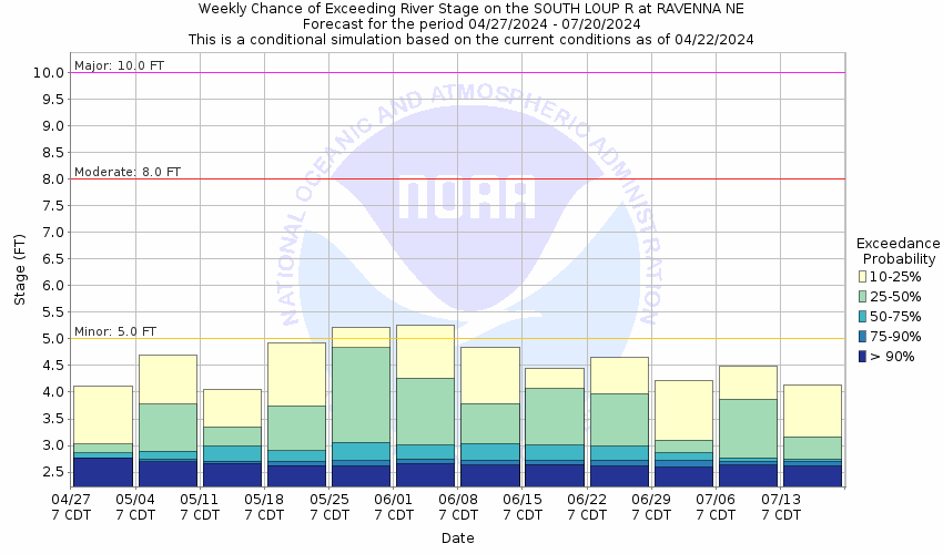
9.5
The outskirts of Ravenna between the Mud Creek and the South Loup River flood, or roughly the area south of Highway 2. There are several homes and a few businesses in the floodplain.
7.5
A house downstream of the gauge on Maple Road just off of Highway 2 will begin to flood. Ravenna Road around one quarter mile south of the gauge site will begin to flood.
5
Flooding occurs in agricultural lowland near the river.
The National Weather Service prepares its forecasts and other services in collaboration with agencies like the US Geological Survey, US Bureau of Reclamation, US Army Corps of Engineers, Natural Resource Conservation Service, National Park Service, ALERT Users Group, Bureau of Indian Affairs, and many state and local emergency managers across the country. For details, please click here.
NWS Information
National Weather Service
Hastings Weather Forecast Office
6365 Osborne Drive West
Hastings, NE 68901
(402) 462-2127 Ask Questions/Webmaster
Page last modified: 2-Nov-2020 7:29 PM


