Skip Navigation Link weather.gov  
NOAA logo - Click to go to the NOAA homepage National Weather Service NWS logo - Click to go to the NWS homepage
Advanced Hydrologic Prediction Service
Image background of Navigation bar Left
Navigation Bar End Cap


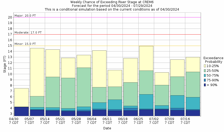
This probabilistic forecast is issued by the Lower Mississippi River Forecast Center.
tab left off Hydrograph tab right off tab left off River at a Glance tab right off tab left off Download tab right off tab left on tab right on
About this graph
Forecasts for the East Hobolochitto Creek near Caesar are issued routinely year-round.
Return to Area Map

Zoom Level:16
Flood Categories (in feet)
Major Flood Stage: 20
Moderate Flood Stage: 17
Flood Stage: 15
Action Stage: 12
Low Stage (in feet): -9999

Historic Crests
(1) 21.53 ft on 09/02/2012
(2) 21.50 ft on 08/31/2012
(3) 20.08 ft on 08/30/2005
(4) 19.61 ft on 08/31/2021
(5) 19.45 ft on 01/08/1998
Show More Historic Crests

(P): Preliminary values subject to further review.

Recent Crests
(1) 17.48 ft on 01/26/2024
(2) 15.56 ft on 02/05/2022
(3) 17.17 ft on 09/16/2021
(4) 19.61 ft on 08/31/2021
(5) 16.05 ft on 07/22/2021
Show More Recent Crests

(P): Preliminary values subject to further review.

Low Water Records
(1) 2.21 ft on 10/05/1999
(2) 2.50 ft on 09/25/1999
(3) 3.07 ft on 09/05/2009
(4) 3.13 ft on 10/17/2007
(5) 3.23 ft on 07/21/2006
Show More Low Water Records
KML Image
Gauge LocationGauge Map Marker
Disclaimer
Latitude/Longitude Disclaimer: The gauge location shown in the above map is the approximate location based on the latitude/longitude coordinates provided to the NWS by the gauge owner.
Flood Impacts & Photos Collapse
If you notice any errors in the below information, please contact our Webmaster
21.53 Flood of record occurred on September 2, 2012.
20 Major flooding with several homes and business structures flooded. Low places on MS Highway 43 will be under water.
17 Moderate flooding in areas near the stream in Picayune. Water will be in garages of several homes between MS Highway 43 and Beech Street bridge. Northwood Drive will be impassable with some homes flooded.
15 Water over a few roads in the city of Picayune will cause traffic problems. School bus traffic may need alternate routes. A few homes on Northwood Drive will be threatened. Beech Street and Westchester Subdivision below the confluence of the east and west branches is subject to flooding in low places.
12 Water will pool on isolated low areas of unimproved roads near the creek. Minor overflow will occur in agricultural areas near stream.
10 Bankfull at gage. Some minor overflow will occur in flood plain downstream of gage.

Other Real-time and/or Archive Data Sources:

Collaborative Agencies Collapse
The National Weather Service prepares its forecasts and other services in collaboration with agencies like the US Geological Survey, US Bureau of Reclamation, US Army Corps of Engineers, Natural Resource Conservation Service, National Park Service, ALERT Users Group, Bureau of Indian Affairs, and many state and local emergency managers across the country. For details, please click here.
NWS Information
National Weather Service
New Orleans/Baton Rouge Weather Forecast Office
62300 Airport Rd.
Slidell, LA 70460-5243
(504) 522-7330
Ask Questions/Webmaster
Page last modified: 2-Nov-2020 7:29 PM
Disclaimer
Credits
Glossary
Privacy Policy
About Us
Career Opportunities