Skip Navigation Link weather.gov  
NOAA logo - Click to go to the NOAA homepage National Weather Service NWS logo - Click to go to the NWS homepage
Advanced Hydrologic Prediction Service
Image background of Navigation bar Left
Navigation Bar End Cap


This probabilistic forecast is issued by the California Nevada River Forecast Center.
tab left off Hydrograph tab right off tab left off River at a Glance tab right off tab left off Download tab right off tab left on tab right on
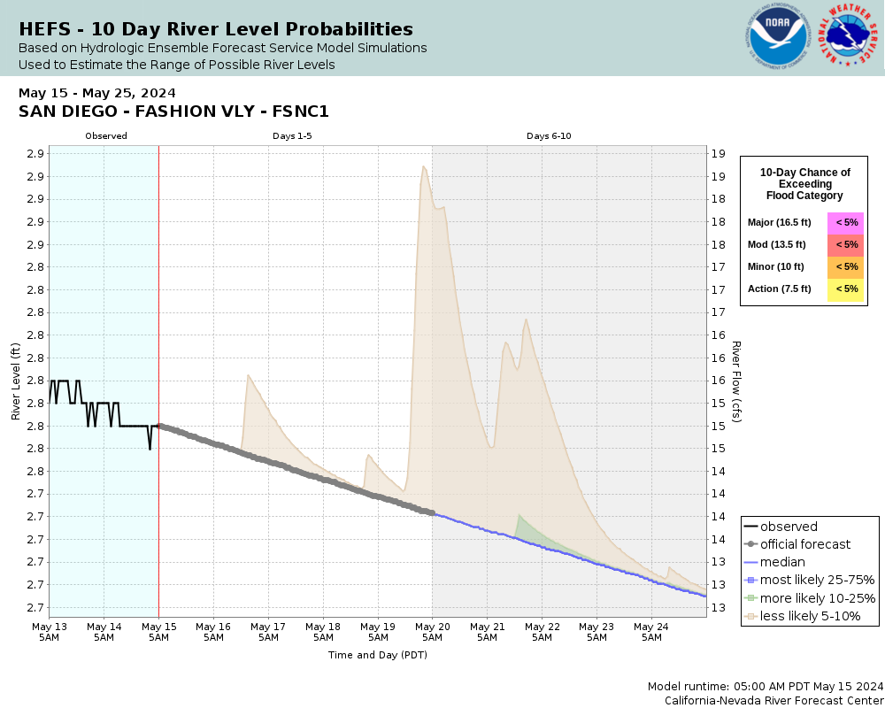
Experimental Short Range Forecast Uncertainty (AHPS) - External Links: Product Description Document | Customer Survey
About this graph
Forecasts for the San Diego River at Fashion Valley are issued routinely year-round.
Return to Area Map

Zoom Level:16
Flood Categories (in feet)
Major Flood Stage: 16.5
Moderate Flood Stage: 13.5
Flood Stage: 10
Action Stage: 7.5
Low Stage (in feet): -9999

Historic Crests
(1) 19.30 ft on 01/27/1916
(2) 16.30 ft on 02/21/1980
(3) 14.15 ft on 02/28/2017
(4) 14.01 ft on 12/22/2010
(5) 13.48 ft on 02/21/1914
Show More Historic Crests

(P): Preliminary values subject to further review.

Recent Crests
(1) 10.40 ft on 03/21/2023
(2) 10.26 ft on 03/15/2023
(3) 8.45 ft on 02/25/2023
(4) 12.77 ft on 01/16/2023
(5) 10.16 ft on 01/01/2023
Show More Recent Crests

(P): Preliminary values subject to further review.

Low Water Records
(1) 1.50 ft on 03/31/1998
(2) 1.67 ft on 09/03/2014
KML Image
Gauge LocationGauge Map Marker
Disclaimer
Latitude/Longitude Disclaimer: The gauge location shown in the above map is the approximate location based on the latitude/longitude coordinates provided to the NWS by the gauge owner.
Flood Impacts & Photos Collapse
If you notice any errors in the below information, please contact our Webmaster
16.5 Most unelevated roads and intersections in Mission Valley are flooded and impassable. Widespread damage to businesses, residences and roads throughout Mission Valley. Water will reach up to Highway 163.
13.5 Portions of Hotel Circle Road North under water. Qualcomm Way flooded and may close. Snapdragon Stadium parking may flood (likely not now) and water may back up on Chollas Creek. Mission Gorge Road at low water crossing closed with 1-2 feet of flowing water. Mission Center Road will have 2-3 feet of flowing water. Hotel Circle Road has areas of standing water.
12 Even more extensive road flooding occurs in and around Mission Valley. Qualcomm Way, Camino Del Este, Ward Road, and Mission Gorge Rd flooded. Mission Trolley Station flooded and may close due to flowing water. I-5 on and off ramps flooded at the San Diego River and Pacific Highway. Mission Center Road may begin flooding with debris on railings. Fashion Valley Trolley Station surrounded by water. 2 feet of water flowing over Fashion Valley Road across gates. Old golf course has been flooded at this level.
11 The parking garages in Fashion Valley Mall can have up to 3 feet of water on the lowest levels. Water may begin to surround area hotels such as the River Leaf Inn. The Mission Trolley Station on Ward Road may begin to flood. Flooding begins on Camino De La Reina (under Highway 163).
10 More extensive flooding begins at this level, more than just low lying areas. Fashion Valley Mall parking garage is taking on water at the lower levels, with 1 to 2 feet of water in the garage. Water on the Town and Country hotel parking lot adjacent to the river and USGS gage.
9 More extensive low lying road flooding begins in and around Fashion Valley including Fashion Valley Road. Parking structures in and around Fashion Valley Mall can begin to take on water at the lowest levels.
7.5 Action stage. The first real impacts are seen on the San Diego River at this level. Low lying roads in and around Fashion Valley Mall begin to take on water. Avenida Del Rio is the first road to begin flooding.

Other Real-time and/or Archive Data Sources:

Additional Information Collapse
Barricades needed on Camino Del Este and Avinida del Rio at Action stage.

Note: The 1980 historic crest was based on Flood Control Engineering Measurements and not USGS records.
Collaborative Agencies Collapse
The National Weather Service prepares its forecasts and other services in collaboration with agencies like the US Geological Survey, US Bureau of Reclamation, US Army Corps of Engineers, Natural Resource Conservation Service, National Park Service, ALERT Users Group, Bureau of Indian Affairs, and many state and local emergency managers across the country. For details, please click here.
NWS Information
National Weather Service
San Diego Weather Forecast Office
11440 W. Bernardo Court, Suite 230
San Diego, CA 92127
(858) 675-8700
Ask Questions/Webmaster
Page last modified: 2-Nov-2020 7:27 PM
Disclaimer
Credits
Glossary
Privacy Policy
About Us
Career Opportunities